UAV + Aerial Hyperspectral Research and Application Prospects
This article mainly introduces the application of the Headwall Co-aligned400 ~ 2500nm hyperspectral imager mounted on the Foxtech Robot V10 and D20 drones. The Foxtech Robot V10 and D20 models have well solved the application problems of large-load and long-endurance flight platforms. Let the popularization of large-area, high-quality hyperspectral applications be realized. Hyperspectral data is widely used in many fields such as agriculture, forestry, military, geology and mining, emergency response, and land planning due to its characteristics of flexibility, high resolution, and operation under the cloud. Foxtech Robot V10, D20 UAV + hyperspectral imager, imaging and scanning in the working area can quickly acquire reflectivity data of ground objects, and use the imager's built-in high-precision inertial navigation (IMU/GPS) to correct imaging distortion, thereby achieving lossless, original Identify ground objects efficiently and accurately.
Introduction
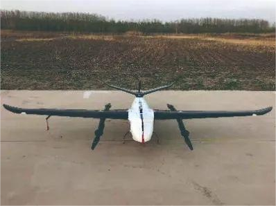
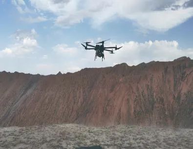
V10/D20 is a newly developed large-load, long-endurance, multi-functional, high-precision, and high-efficiency UAV system by Foxtech Robot - V10 is a large-load vertical take-off and landing UAV system, and D20 is a large-load rotary-wing UAV system. The two UAV systems focus on "large payload and long endurance" and continue the industrial and modular design of Foxtech Robot products. They use universal intelligent power batteries and high-end payload equipment, and can be equipped with visible light aerial survey modules, visible light tilt modules, visible light Video modules, thermal infrared camera modules, thermal infrared video modules, multispectral modules, hyperspectral modules, lidar modules, synthetic aperture radar modules and some combination modules are all equipped with high-precision differential GNSS boards and standard network RTK/PPK and Its integrated solution service supports high-precision POS-assisted aerial triangulation, and has the capability of 1:500 large-scale mapping without control points, enabling image control-free applications; both are equipped with the "Drone Manager Professional Edition (Measurement Edition)" software , supports intelligent routes and joint route planning based on accurate three-dimensional terrain to meet various application needs, and has the ability to follow precise terrain and three-dimensional real-time flight monitoring; supports GPS fusion calculation, control point measurement, aerial triangulation calculation, and one-click It has functions such as mapping, one-click export of stereoscopic mapping, high-precision integrated navigation trajectory calculation, point cloud processing and classification, etc., and provides processing and browsing of various data results such as DOM, DEM, DSM, TDOM, LAS point cloud, etc.
The HeadWall Co-aligned 400-2500nm hyperspectral imager is a full-spectrum imager produced by the American company HeadWall. It is currently the only UAV airborne 400-2500nm imager in China. HeadWall Company mainly produces gratings, spectrometers and other products, which are widely used in remote sensing, military and national defense, machine vision, biomedicine and other fields. HeadWall Co-aligned 400-2500nm imaging method is classic line sweep imaging, and each pixel corresponds to an accurate spectrum that is actually collected. Adopting a total reflection concentric optical design, it has a compact structure, less stray light, and a higher signal-to-noise ratio. It has no movable parts such as mechanical shutters, strong impact resistance, and integrated maps. Each pixel is a real collected spectrum, with spectral resolution. The efficiency is high, the spectral feature information is richer and more reliable, the smile and keystone distortion of the phase difference correction image is minimized, and the original scratched grating is used to reduce the noise. The entire spectrometer system is small in size, highly integrated, and can be adapted to laser Lidar synchronization. To obtain hyperspectral and point cloud data, the two data fusion processes can also be performed. Compared with common hyperspectral instruments, HeadWall Co-aligned has the following advantages: (1) wide band range, 400-2500nm; (2) light equipment, weighing only 2.8kg; (3) high integration, instrument integration It has high-precision inertial navigation, 400-2500nm imager, and laser LIDAR; (4) Really collect the spectra of ground objects.
Hyperspectral Signature
Different substances have different compositions of molecules, atoms, and ions, and the light energy distribution reflected or absorbed in the same spectral range is also different. From the characteristics of the spectral curve, the reflection or absorption spectral curve of an object shows regular changes with the change of wavelength. , that is, the characteristic peaks and troughs on the spectral curve. Hyperspectral imagers can identify the differences in these energies, similar to human fingerprints. Based on the "spectral fingerprints" of different substances, spectral features are extracted by analyzing the spectral features of the spectral data. Parameters, thereby realizing the identification and differentiation of research objects.
HeadWall Co-aligned acquires the visible-short-wave infrared spectrum signal of 400-2500nm of ground objects. Based on the spectral fingerprint of ground objects, it can quickly extract and analyze ground object information, such as altered minerals, pollutants, camouflage, vegetation and other types of ground objects. information extraction, etc.
The UAV hyperspectral operation process starts from the work purpose and task, selects the target area, selects a multi-rotor or fixed-wing UAV according to the size and model of the target area, and plans the route of the UAV. The data acquisition method of the imager is to continuously push and broom the camera to acquire the spectrum of ground objects. After the flight mission is completed, the VNIR, SWIR and inertial navigation data are downloaded, and then the reflection spectrum data is converted into images for display through technical means, and then the hyperspectral data are processed In preprocessing, a ground object spectral feature recognition model is established based on the spectral fingerprint characteristic spectrum and ground object spectral data, and then the unknown area is inverted and predicted. The specific flow chart is shown in Figure 2.
UAV hyperspectral processing process
Radiance and Reflectance
The hyperspectral imager adopts a total reflection concentric optical design with small phase difference and uses specially designed optical elements. The acquisition error does not exceed one pixel, which basically eliminates the distortion of smile and keystone. The light passes through the slit, is split by the grating, and hits the sensor to generate two-dimensional data: spatial dimension and spectral dimension. The slit corresponds to a line on the ground. According to the movement trajectory of the drone, the line moves into a surface, that is, the two-dimensional spatial dimension and the one-dimensional spectral dimension are obtained, and finally a hyperspectral data cube is obtained.
The reflected light from ground objects enters the sensor of the hyperspectral imager, and the optical signal is converted into an electrical signal to obtain the original DN value of the sensor. The software SpectralView is used to complete the conversion of the DN value to radiance. Since the response of each pixel of the sensor is uneven, the manufacturer will use a uniform integrating sphere to calibrate the radiance before leaving the factory to achieve uniformity of each pixel, and convert the original DN value without units into a radiance value with units. , and can be compared with other devices, the DN value is converted into radiance.
In order to characterize the spectral fingerprint of ground objects, it is necessary to convert the radiance value into reflectance. This process requires the use of targets for comparison. Generally, three targets with different reflectivities (such as white cloth, gray cloth, and black cloth) are used. Each piece has a Known reflectivity, by simultaneously collecting the spectrum of the ground object and the spectrum of the target, the software SpectralView can be used to obtain the reflectance of the ground object. The reflectance of the ground object.
Affected by the weather, the drone cannot maintain a stable attitude from beginning to end, and various changes will occur, such as roll, pitch and yaw during the flight of the drone, resulting in various deformations, distortions, etc. in the acquired images. HeadWall comes with high Precision inertial navigation GPS/IMU records attitude and position information for image correction. At the same time, HeadWall also integrates 16-line laser Lidar for simultaneous flight, recording three-dimensional point cloud data and vertical structure information with a height of less than 100m, and ultimately achieving high-precision image correction. High-precision inertial navigation can be combined with ground base stations to achieve post-PPK differential through POSPac UAV software to improve positioning and attitude accuracy. Use SpectralView software to combine the sensor's field of view and instantaneous field of view, and restore the true position of each frame through the position information and attitude information of the flight at that time, thereby completing orthorectification.
Data fusion can fuse terrain data obtained by laser Lidar and hyperspectral data. In the false color image, the red channel highlights steep features (cliffs, trees), and the green and blue channels magnify the differences in vegetation and land. Additionally, DEM data is added to the data cube as a channel.
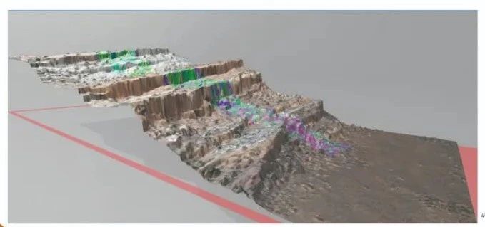
Fusion of terrain and hyperspectral data
Application Areas and Cases
UAV hyperspectral is widely used in various aspects such as monitoring and early warning, geological prospecting, military camouflage identification, feature classification, environmental pollutant information extraction, agricultural yield estimation, growth status monitoring, forestry tree species identification, construction planning, project site selection, etc. , select several cases for analysis below.
Forestry health monitoring
To monitor the health of pine forests, it is impossible to distinguish between the green and general visible light images of pine trees in the early stages of disease and healthy pine trees. Instead, an airborne imager is used to test the reflectance spectrum of the healthy pine leaf canopy , and the canopy reflectance spectrum of diseased pine trees was also tested (Figure 9 middle). Healthy pine trees grow vigorously, have sufficient water in their leaves, active chlorophyll cells, and have relatively strong reflections in the green and near-infrared bands. Diseased pine trees have relatively strong reflections in the green and near-infrared bands. Due to being eroded by insect pests, pine trees have weak vitality, low leaf moisture, inactive chlorophyll cells, yellow color, and low reflectivity in green and near-infrared bands. Based on two different characteristics, combined with the spectral characteristics extracted from the ground, we can obtain the diseased pine trees. and the spectral fingerprint characteristics of healthy pine leaf canopy, establish a relevant spectral model, obtain large-area spectral image data through UAV hyperspectral, and conduct inversion based on the model to realize the investigation of the health status of pine trees in a large target area.
Disguise identification
Camouflage identification of ammunition piles. This is the Saab Barracuda camouflage net above the ammunition pile. After using conventional RGB shooting, the camouflage target blended with the ground background and visually "disappeared" into the background, making it impossible to identify the camouflage target. Since the camouflage net is in the full spectrum range of 400-2500nm, which is different from the ground background, UAV hyperspectral is used to obtain images for processing, suppressing background information, and at the same time separating and amplifying spectral anomalies, thereby isolating the camouflage target from the background. , making the camouflaged target visible.
Feature classification
Regarding the classification of crops. Based on ground experiments, ground spectrometers were used to measure the spectra of various crops such as barley, potatoes, oats, alfalfa, rape, and spinach to obtain spectral fingerprint characteristics, and then a drone hyperspectral system was used to obtain "unified spectra" spectral images of crops, based on spectral fingerprint features, various crops can be classified through SAM spectral angle calculation.
Prospecting for minerals and treasure
Due to the huge differences in the atomic composition of different minerals, there are obvious differences in 1000-2500nm. Hyperspectral technology is also the first to show its strength in the field of mineral identification. Currently, the internationally accepted spectral library is also based on mineral spectra. On the basis of the spectral library Using a spectrometer, metals such as iron ore, copper ore, and gold can be identified non-destructively on site.
Alteration is an important sign of mineral prospecting. Different altered minerals have different spectral fingerprints. Hydrothermal deposits are all related to alteration. UAV hyperspectroscopy can be used to obtain spectral fingerprints of ground objects, as well as altered minerals and their properties. Combined spectral characteristics to achieve the goal of large-area prospecting.
Soil moisture content estimation
SoilMoisture Content (SMC) is an important physical parameter of soil and a key constraint on soil aggregate structure and nutrient status. SMC will affect the physical and chemical physiological processes of soil. Understanding the exact soil moisture status of farmland can more effectively manage the irrigation system of farmland. Targeted improvement of soil moisture status at critical stages of crop growth can improve crop yield and quality. Samples are uniformly sampled in the farmland, processed and dried in the laboratory. Some samples are taken to maintain the model set, and some samples are used as verification sets. After filtering and denoising, the average spectrum is taken for each sample area, and different spectral indexes are used to select and estimate soil moisture. The best band of soil moisture content, and based on this, a quantitative estimation model is established to invert the soil moisture content.
The V10 and D20 UAVs have well solved the application and mounting problems of large-load, long-endurance flight platforms. HeadWall Co-aligned 400-2500nm hyperspectral imaging instrument has wider spectral data than 400-1000nm equipment. It can simultaneously acquire 400-1000nm and 1000-2500nm hyperspectral data with the same ground resolution, and has higher accuracy in identifying spectral fingerprint information. higher. The UAV + HeadWall Co-aligned 400-2500nm hyperspectral imager can provide large-area high-quality hyperspectral data and can be widely used in agriculture, forestry, geological prospecting, archaeology, urban planning, environmental monitoring and early warning and other fields.
