Application of UAV Aerial Survey Technology in Comprehensive Pollution Control Work in Open-Pit Mines
Background of the Project
Necessity of the project
1. The control area belongs to a lost mine that has been closed by the responsible party. The location and nature of the control area are in line with the spirit of the notice of the Ministry of Land and Resources’ “Regreening Mines” action plan and the rectification tasks for outstanding mine environmental problems around the “three zones and two lines” category.
2. The treatment area is open-pit mining, which has caused serious damage to the landscape and land resources. The rocks are directly exposed on the surface and are severely weathered. The surface has been weathered into the earth. In the dry seasons of spring and autumn, dust rises everywhere, forming a source of sandstorms and haze materials. It has caused serious pollution to the atmosphere and requires urgent "mining greening" treatment.
3. The riddled topography of the treatment area is extremely inconsistent with the famous tourist city of Qinhuangdao, the Pearl of the Bohai Sea. It is also an urgent desire of the local people to "regreen the mine" in the area and change the ecological environment.
In view of this, it is important to further enhance the image of Qinhuangdao City as a civilized city, identify the impact of these mines on the geological environment and the environmental and ecological damage caused, eliminate hidden dangers of geological disasters, create a harmonious natural landscape, and improve the ecological environment. The urgent requirement of county economic construction. Therefore, it is urgent to carry out mine geological environment restoration and management. It is not only necessary but also a very urgent task facing the government.
Through the implementation of the project, the damaged geological environment of the mine has been treated, potential geological hazards have been effectively controlled, slag and waste residues have been reasonably stacked and utilized, the topography and landscape of the mining area have been beautified, and the ecological environment of the mine has been repaired and improved, which will contribute to the reduction of dust. It is of great significance to reduce pollution, improve ambient air quality, improve the ecological environment around the "three districts and two lines", and promote the sustainable development of the local economy.
To sum up, with the support of special national funds, this project is technically and economically feasible and can achieve the expected purpose. The project has significant social, economic and environmental benefits.
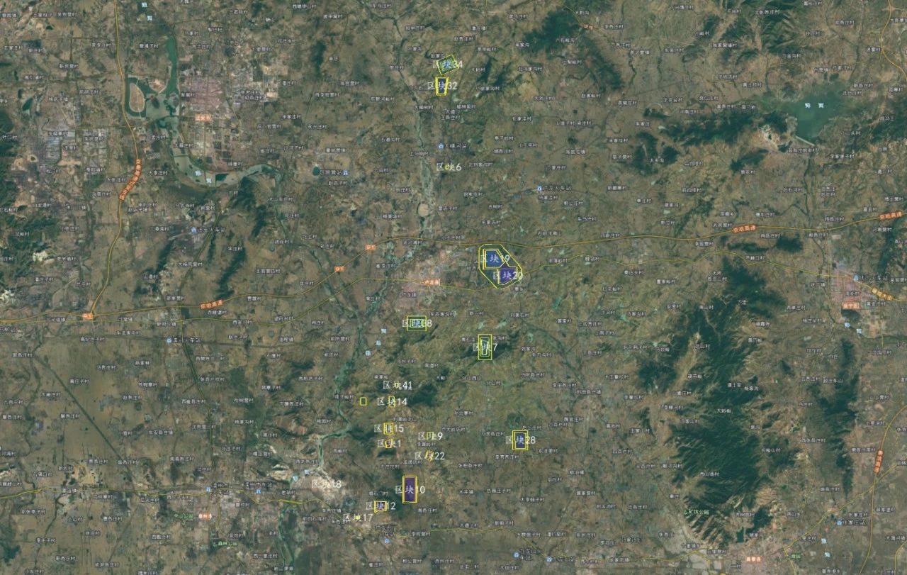
In accordance with the requirements of the "Notice of the Department of Natural Resources of Hebei Province on the Comprehensive Management Tasks of Responsible Subjects' Lost Mine Sites in 2020" and in combination with the "Summary Table of Comprehensive Management Tasks of Responsible Subjects' Lost Mine Sites in Qinhuangdao City in 2020", the County's Natural Resources and Planning Bureau 30 mining sites are undergoing engineering treatment. The current status of the project area before treatment is as follows:
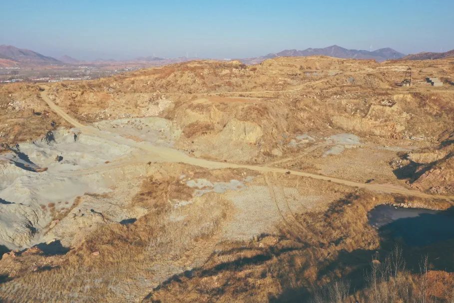
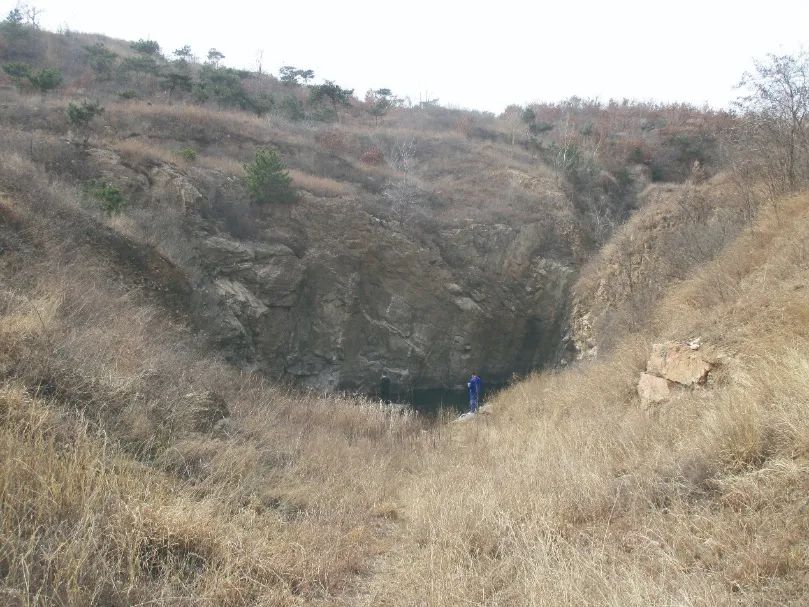
Photos of the current situation of the mine
Technical Route
Measurement Work Content
(1) Measure, collect and analyze the topography, stratigraphy lithology, geological structure and other data related to the project, and understand the physical geography and regional geological environment conditions of the project area;
(2) Identify the mining geological environmental problems and hazards caused by mining activities through topographic surveys and ground surveys, and evaluate development trends; identify tunnel faces, slag piles, mining pits, mining steps and platforms, scum, The distribution location and scale of solitary rocks and residual mountains, as well as the degree of damage to surface vegetation, land resources, and landscapes, identify possible secondary disasters such as dangerous rock (rock) bodies and unstable slopes, and evaluate them Stability; prepare plan plans, sections and other related drawings required for governance engineering design;
(3) Investigate construction conditions such as water and electricity, construction roads, work sites, and project land area in the project area
Job Difficulty Analysis
-Construction period difficulty analysis
This project has a tight construction period and high requirements for technology and implementation quality. How to ensure that the work goals of this project are achieved within the most reasonable time. Guaranteeing the construction period will be the difficulty in the implementation of this project. Improving the measurement construction method and arranging personnel to group and implement it are The best way to ensure construction deadlines.
Project Implementation Difficulty Analysis
The project areas are all abandoned mines that have been abandoned for many years. Most areas are overgrown with weeds. The current status of tailing pits and mine tunnels is unknown, and there are safety hazards during construction.
Based on the above analysis, it is particularly important to choose a working method with a short working cycle, reliable quality and high safety, which will directly affect the total cycle of the project.
The main content of the survey work of this project is to measure the current situation of terrain and features, and ultimately provide usable topographic maps to provide basic data for the design department. Time is tight and the task is heavy. How to quickly and safely obtain stolen project terrain materials? Through inquiries from the land and surveying and mapping departments, most of the project areas currently have no relevant data, or some of the data are old and not current. Taking doctrine directly will not work. Using traditional methods to collect all-field data requires a large amount of manpower and material resources in the project area of more than ten square kilometers, and the existing features are easy to lose, and the safety risks for project implementation personnel are also high.
Through comparison and comprehensive consideration, the only available method is to use drone aerial photogrammetry. Convenient, efficient, safe and quality guaranteed.
Project Work Process
Determine the scope of the survey area
The scope of this measurement covers the current status of 30 abandoned mines, including open-air tailings slag piles and mining pits. The distribution of each mine is relatively scattered. The work scope is imported into the Foxtech Robot drone steward system based on the owner's existing coordinates.
On-site field investigation
On-site field investigation is mainly to understand in detail the traffic conditions in the survey area, observation conditions in the survey area, determine the take-off and landing locations, observe ground objects, altitude, terrain, vegetation, etc.
Route Design
Based on the preliminary survey area conditions, air routes are planned and designed, including route direction, flight altitude, etc. The design scale of this measurement is 1:500, the design route heading heavy fragrance rate is 80%, the side heavy fragrance rate is 65%-70%, and the relative average flight height is 150 meters. On the premise of ensuring flight safety, the highest accuracy is possible Aerial photogrammetry of the current situation.
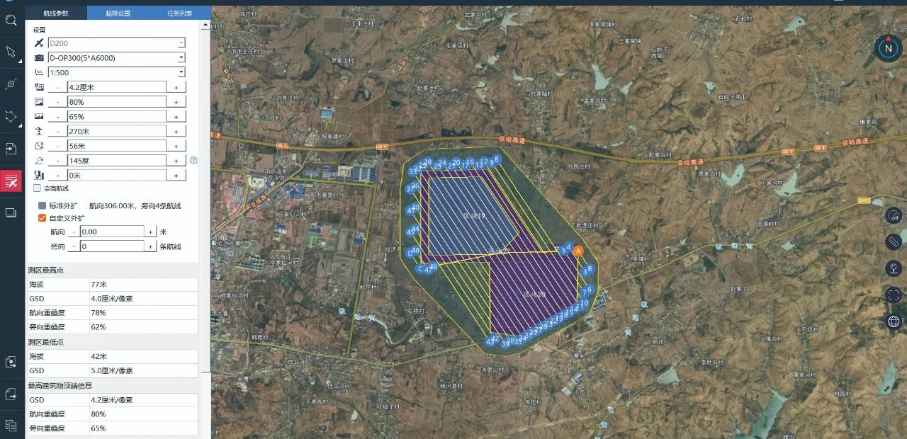
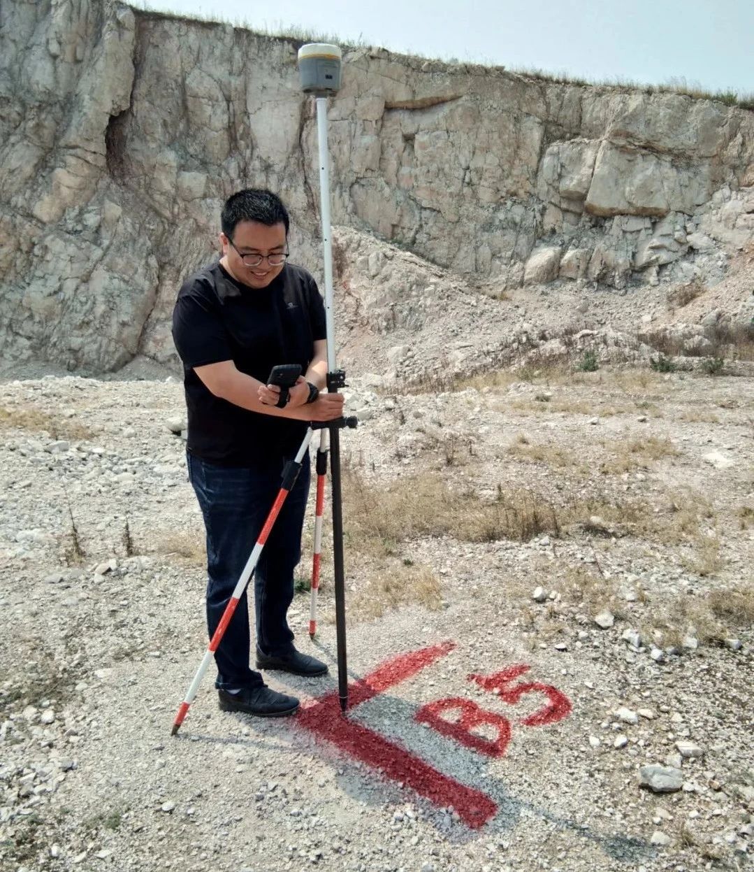
Image control point layout and testing
When using drones for aerial photography, image control points are often required. The accuracy and number of image control points directly affect the accuracy of post-processing of aerial survey data. Therefore, the layout and selection of image control points should be standardized, strict, and precise. Generally, you can choose oil-based spray paint for field image control points according to your needs. The color of the spray paint should be specifically selected according to the conditions of the measurement area. It is better to choose a color with a large color contrast. After finishing the image control points, take 2-4 photos from different angles. , it is best to have a reference object to facilitate internal processing.
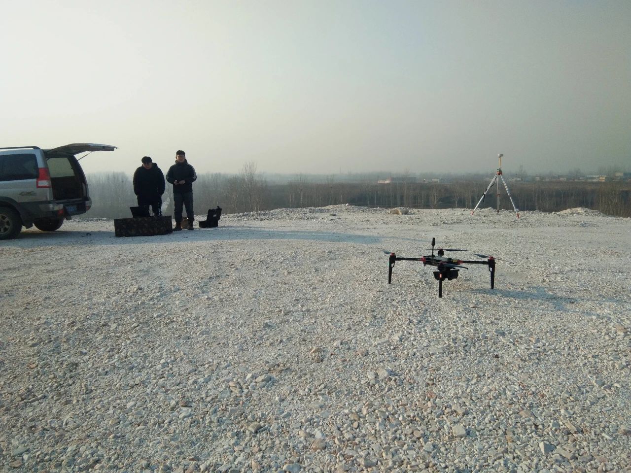
UAV field aerial survey
After the layout of image control points is completed, field aerial survey work will be carried out in a timely manner according to weather conditions. The aerial survey uses the "intelligent flight" module of Foxtech Robot drone steward. The operation process is: aircraft assembly - base station erection - takeoff inspection and debugging - flight monitoring - data download and inspection after flight completion. The operation process is strictly carried out in accordance with the regulations.
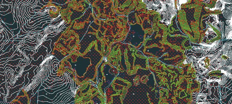
Topographic map drawing uses fully digital three-dimensional mapping equipment and software to collect data on all elements of surface objects and landforms. After outside mapping and supplementary surveying, the in-house industry uses professional mapping software for data editing and other work to obtain a 1:500 topographic map. , the final results are as follows:
Summary of Project Features and Advantages
This project is implemented by the province and city in order to implement the spirit of the 19th National Congress of the Communist Party of China, accelerate the construction of ecological civilization, continue to promote the comprehensive control of pollution from open-pit mines in the province and win the battle to defend the blue sky with a decisive attitude. The time is tight and the task is heavy. Errors or delays in any aspect of survey, design, and construction will have a series of adverse consequences. How to efficiently complete the tasks assigned by superiors is a must-answer question for governments at all levels.
Through the use of UAV aerial survey technology in the preliminary survey of this project, the advantages have been concentratedly reflected, as follows:
1. Short measurement time and high efficiency. If this project adopts traditional surveying methods, it would take at least 3 months to invest a team to measure the entire project site. After using drone aerial survey technology this time, a total of one survey team will be invested, and the field aerial survey and aerial survey data processing will take a total of 15 days. This greatly saves time and cost, and buys time and space for subsequent design and construction.
2. Less personnel investment and significantly reduced measurement costs. If this project uses traditional measurement methods, it will inevitably invest a lot of manpower and material resources, and the cost will be very high. After using drone aerial survey technology, only one measurement team and one vehicle are invested, and the remaining personnel are actively invested in in-house processing drawings, which greatly saves money. of human, material and financial resources.
3. The current situation of surveying and mapping is comprehensive and the quality is guaranteed. If traditional surveying methods are used in this project, there will inevitably be areas that cannot be reached due to natural landforms, vision conditions, etc., resulting in inaccurate measurements. By using drone aerial survey technology, the entire mine scene can be integrated into one image. , the current situation is clear at a glance, and can be browsed and edited to avoid missing and missing features.
4. Personnel do not have to be present for every test, and safety is significantly improved. If traditional measurement methods are used in this project, personnel will be able to measure wherever they go, and they will be there every time. The measurement area is all abandoned mines for many years, and the mines and mines are unknown, so there are potential risks for personnel walking. After using drone aerial survey technology, the survey team only needs to find a relatively flat area in the project area where drones can take off and land. As soon as the aircraft goes up and down, the field survey is completed, and safety is significantly improved.
5. The resulting images can be reused by other departments. The design department can directly check the actual status of the mine through the image map, which greatly saves the personnel and time costs of on-site inspections; government departments such as land and resources can directly check the actual status of the mine through the image map, providing basic guarantee for scientific decision-making and judgment.
In summary, the use of UAV aerial survey technology in the measurement work of this project has saved time, reduced costs, ensured the quality of results, and ensured the safety of personnel. It has made a positive contribution to the smooth implementation of the project and has also provided benefits to the company and related parties. The unit's implementation of similar projects such as comprehensive pollution control in open-pit mines and environmental management provides a good reference experience.
