The First Surveying, Mapping and Geographic Information Conference concluded successfully
From November 8th to November 10th, the first China Surveying and Mapping Geographic Information Technology and Beidou Application Expo concluded successfully at the Zhejiang Deqing International Exhibition Center. This expo is co-sponsored by the China Society of Surveying and Mapping, the China Geographic Information Industry Association, and the China Satellite Navigation and Positioning Association. It has an exhibition area of 20,000 square meters and brings together 148 exhibitors, including the main forum, 38 sub-forums, and a technology and industrial development salon. , "Surveying and Mapping Geographic Information + Beidou" Night and China Surveying and Mapping Geographic Information Technology and Beidou Application Expo and many other activities were unprecedented in scale, attracting tens of thousands of participants.
From November 8th to November 10th, the first China Surveying and Mapping Geographic Information Technology and Beidou Application Expo concluded successfully at the Zhejiang Deqing International Exhibition Center. This expo is co-sponsored by the China Society of Surveying and Mapping, the China Geographic Information Industry Association, and the China Satellite Navigation and Positioning Association. It has an exhibition area of 20,000 square meters and brings together 148 exhibitors, including the main forum, 38 sub-forums, and a technology and industrial development salon. , "Surveying and Mapping Geographic Information + Beidou" Night and China Surveying and Mapping Geographic Information Technology and Beidou Application Expo and many other activities were unprecedented in scale, attracting tens of thousands of participants.
On the occasion of the grand event, Foxtech Robot simultaneously released three heavyweight new products in Deqing, Zhejiang on November 7th - intelligent aerial survey system E3000, handheld laser scanner SLAM2000, and tilt photography module DP500. The functions of the three new products have been fully upgraded and can meet the needs of many users. Surveying and mapping needs of industries and multiple scenarios.
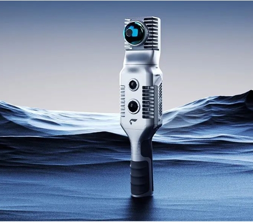
During the conference, the Foxtech Robot booth was very popular, especially the newly released SLAM2000 and other new products that attracted much attention. SLAM2000 is equipped with a high-performance computing module that can simultaneously construct real-time mapping during the data collection process. It also introduces a visual camera for the first time, and with the newly developed SLAM algorithm, it can greatly improve the mapping capabilities of scenes with weak structural features and greatly enrich the applicable scenarios of SLAM2000.
At the exhibition, Foxtech Robot not only presented a number of new products such as SLAM2000, but also exhibited high-efficiency, long-endurance vertical take-off and landing fixed-wing UAV systems V10 and V500, multi-rotor UAV systems D20 and D2000S and many payloads. The equipment comprehensively demonstrated Foxtech Robot's product matrix and product strength as a "one-stop spatial data solution service provider" and received deep recognition and high praise from many participating leaders, experts, and industry colleagues.
During the exhibition, Foxtech Robot won two important honors, including the first prize of the Geographic Information Technology Progress Award and the title of Top 100 Enterprises in the Geographic Information Industry in 2023, which fully reflected Foxtech Robot's product technical strength and good development trend.
E3000 is an intelligent aerial survey drone system independently developed by Foxtech Robot equipped with a mechanical global shutter and an APS-C format aerial survey module. It has more outstanding imaging quality, more diverse route shooting modes, more independent imaging control and real-time POS stamping. Capabilities, aerial survey and video application experience have been fully upgraded.
DP500 is the first oblique photography module adapted to the DJI drone platform developed by Foxtech Robot based on market demand, with a total pixel count of 126 million. This module uses Foxtech Robot's self-developed half-frame camera and is equipped with a surveying-grade lens, which can achieve 1:500 image-free imaging in a variety of complex surveying and mapping scenes such as cities, plains, and mountainous areas with large height differences. DP500 will provide more options for operations and create more value for customers.
