SLAM2000 Project Mapping&Surveying New Trends
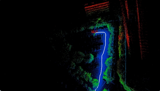
SLAM2000 is another industry-grade laser scanner innovatively developed by Foxtech Robot. This device uses a hemispherical non -heavy -dularly scanning laser sensor, combined with rotating gimbal platforms to achieve 720 ° without dead angle cloud coverage; new visual camera can be added to introduce visual SLAM algorithms, which can effectively enhance the three-dimensional reconstruction adaptability of weak structural features; Foxtech Robot industry -grade SLAM algorithm, truly realizes super free scene adaptation and high -precision sweeping and fast construction, providing efficient and accurate solutions for 3D mobile measurement requirements.
Three Major Upgrades
Introduce visual SLAM auxiliary 3D construction map
SLAM2000 introduced visual cameras for the first time. With the newly developed visual SLAM algorithm, it can provide more matching feature points on the basis of laser SLAM to effectively avoid errors caused by repeat and matching errors, which greatly enhances the ability of weak structural features to build charts. The application of the applicable scene of SLAM2000 is great.
The processing algorithm is fully upgraded and improved the accuracy
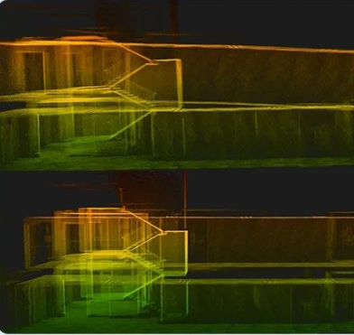
SLAM2000 fully upgrades the SLAM algorithm, and the graphics can output higher accuracy data data to achieve high-efficiency and high-precision scenario data conversion; the color algorithm is optimized and upgraded for different scenarios, and the output true color point cloud is clearer and exquisite.
Functional upgrade meets the needs of multi-industry needs
SLAM2000 configures a high-performance computing module, which can be built in real-time during the data collection process to realize "what you see is what you see, what you see is income". In addition, the SLAM2000 not only supports the handheld and backpack mode but also supports the use of a tripod for stand-type scanning to obtain higher-density and higher accuracy point cloud data to meet the needs of different industries.
High-performance hardware selection
The SLAM2000 uses a more frequent industrial-grade laser radar with a measuring distance of 70 meters. Non-duplex scanning point cloud data is more uniform. With 360 ° rotating gimbal, a 720 ° panoramic laser scan can be achieved; two 1-inch CMOS is selected. The high-definition wide-angle camera of the sensor is used for color and visual SLAM, respectively, and the image quality is clearer; the high-precision habitual chip of Pegasus has built-in Pegasus, which can greatly improve the accuracy of the results; 512GB built-in high-speed storage particles, data storage is more stable.
High-precision results output
Thanks to self -developed high -precision habitual chips, SLAM2000 can effectively suppress the accumulated errors in data collection; comprehensive optimized radar standard fixed algorithms and continuously upgraded industry SLAM algorithms can ensure that SLAM2000 outputs high -precision three -dimensional output high -precision three -dimensional output in various application scenarios in various application scenarios. Achievement.
Slam2000 equipped with a high-performance computing core can be constructed by maps during the process of data collection. After the data collection is completed, it will directly output results data, that is, real-time construction maps can be applied to application scenarios with high time requirements such as emergency rescue Essence.
Extension and adapting more scenarios
SLAM2000 has a variety of external interfaces such as Type-C, and aerospace insertion, and can connect extension modules such as power supply, S-RTK100, backpack, etc. to meet users' more application needs.
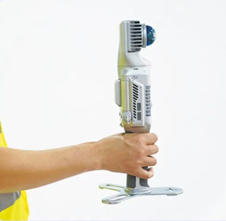
The SLAM2000 uses a safer 3000mAh replaceable smart battery handle to ensure that the SLAM2000 continues to work for 95 minutes. The charging uses the Type-C interface and is equipped with a 65W fast charge device to ensure the power supply of the SLAM2000.

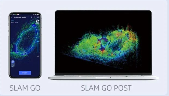
SLAM2000 standards for SLAMGOAPP software and SLAMGOPOST data solution software. Combined with the industry-grade SLAM algorithm can achieve high-precision point cloud results output, coordinate conversion, point cloud fu color, etc. You can also query the work parameters of the device through the mobile app, preview the real-time chart results, perform equipment firmware upgrades and maintenance, etc.