Slam100 Product Software System - SLAM GO POST Pro is Newly Launched
On November 11, 2021, we announced the SLAM100, our first handheld LiDAR scanner. After nearly 9 months of market testing, SLAM100 has gained a place in the fiercely competitive field of handheld lidar scanner products, and has been widely recognized by the industry, and product awareness has been effectively improved.
At present, SLAM100 has been widely used in high-precision surveying and mapping, square calculation, forest resources census, underground space informatization, 3D real scene reconstruction and other application directions. Efficient and convenient measurement methods and relatively complete solutions.
Since the release and sale of SLAM100, we have always paid attention to user feedback and continued to make efforts in product development. Combined with our own product characteristics and customer demand-oriented, after 3 months of combing, demonstration, development and debugging, we carried out a major product reconstruction of the point cloud post-processing software SLAM GO POST supporting SLAM100. The upgraded SLAM GO POST Pro is more systematic, engineering, and intelligent, with a more intuitive interface and an improved interactive experience. The new version of SLAM GO POST Pro is now online, and users can update it online and experience it in a timely manner through Pegasus "Drone Steward Professional Edition".
What are the highlights of SLAM GO POST Pro after this upgrade? Let's find out together.
Intuitive Interface, Enhance Interactive Experience
On the basis of retaining the existing functions of the first generation SLAM GO POST, the software interface and functions of SLAM GO POST Pro have been completely restructured - the new version of the software has an intuitive layout, clear logic, and simple operation, which further improves the human-computer interaction experience. The software consists of four parts: function bar, data management window, main view window and status bar.
♦ The function bar is used for data calculation, viewing, browsing, editing, etc.
♦ The data management window can effectively manage multi-project data and its results.
♦ The main window is used to display point cloud, odometer, video POS, panorama and other results.
♦ The status bar displays the current processing status and progress of the software, processing logs, etc., and the user can perceive the data processing progress in real time.
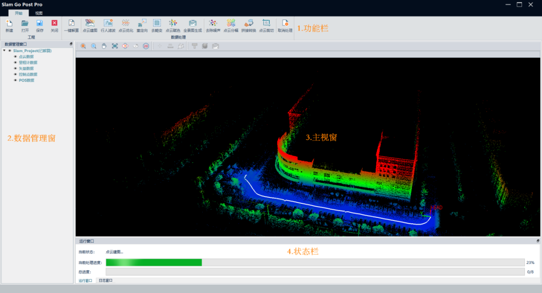
Software Interface Organization
Improve Software System
Integrates engineering, calculation, browsing, inspection and other functions into one to improve software system
Compared with the original SLAM GO POST, SLAM GO POST Pro adds the concept of "project", users can create and edit projects. After the project is created, the software can support engineering data calculation (one-key calculation, step-by-step calculation), data browsing and rendering (view rendering, section), data editing (noise removal, splicing conversion, frame cutting, etc. ), data measurement and other functions, and all functions are systematically structured and effectively integrated, which facilitates the processing and inspection of SLAM data, avoids users from switching between multiple software, and further improves the system solution ability of the software.
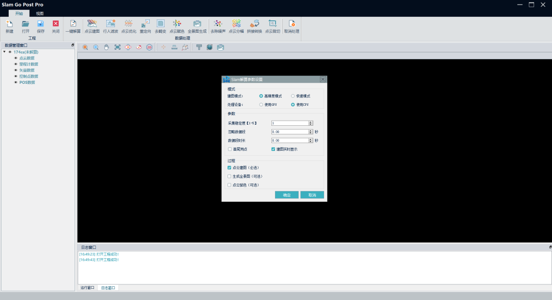
Engineering One-Key Solution
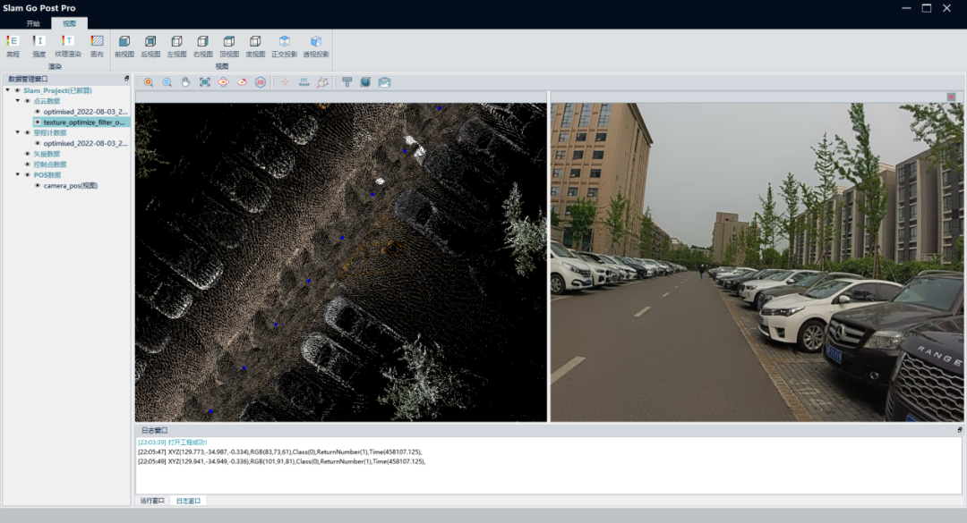
Joint Display of Point Cloud and Panorama

Space Measurement
Meet the Needs of Customers in Different Scenarios
Support multi-project management, one-click and distributed processing, which can meet the needs of customers in different scenarios.
The SLAM GO POST Pro data management window can effectively and clearly manage multi-project data, and solve the problem of management organization and collaborative processing of data scanned multiple times a day by users; it supports two calculation modes of one-key calculation and step-by-step processing, and users can Choose the best solution mode according to your needs.
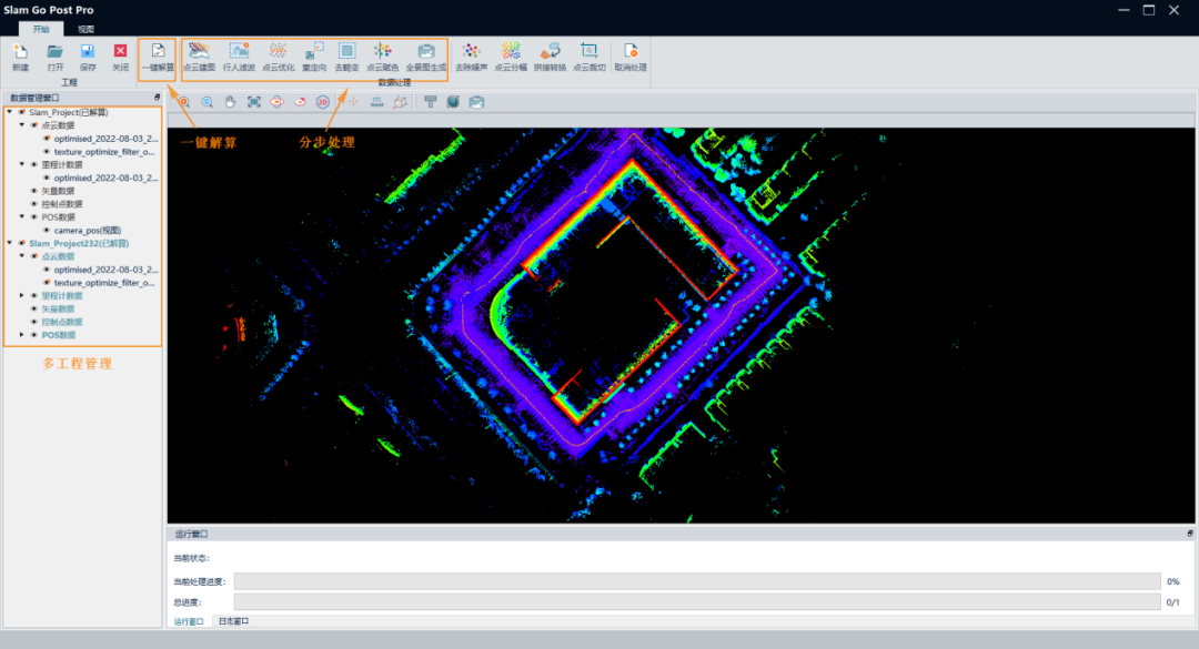
Multi-Project Management and Processing Mode
The meanings of the two calculation modes are as follows:
♦ One-click processing: One-click processing for a certain project, the software will sequentially perform steps such as point cloud mapping, pedestrian filtering, point cloud optimization, and redirection, and directly output the final standard results.
♦ Step-by-step processing: users can independently choose software execution steps according to their own needs. For example, if the user only needs the original point cloud results, he only needs to check [Point Cloud Mapping] to reduce unnecessary processes and improve work efficiency.
Point Cloud Stitching Speed and Accuracy
Manual point selection + intelligent algorithm-assisted registration to improve the speed and accuracy of point cloud stitching
Point cloud registration and stitching is based on manual selection of points as a reference, and the ICP algorithm is used to assist in the calculation of precise points, which can not only improve the calculation speed of the software by narrowing the matching range, but also effectively reduce the error of manual point selection and improve the accuracy of data set stitching.
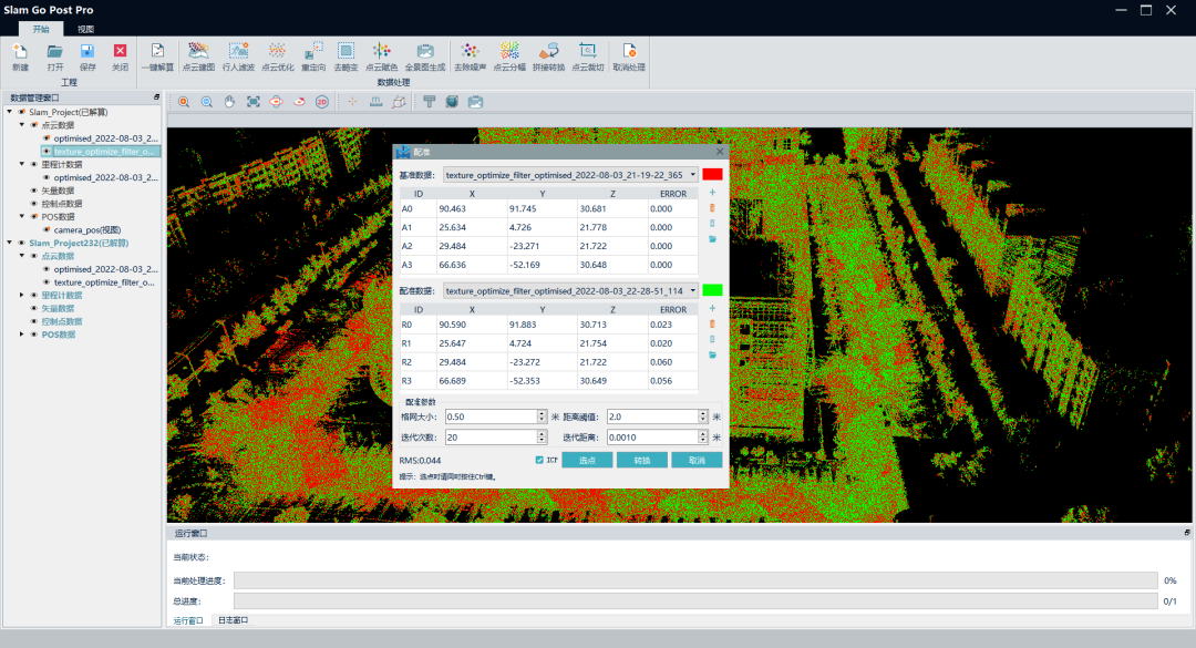
Point Cloud Registration
In the future, SLAM GO POST Pro will also support one-click multi-project batch processing, distributed cluster processing, advanced point cloud rendering, interactive coloring and other functions, and will also support multi-mode applications of SLAM100 derivatives (such as backpacks, Unmanned aerial vehicle, vehicle, etc.) or multi-source data fusion processing (such as external panoramic camera, RTK), continuous service self-contained SLAM product matrix.
