DV-LiDAR10 - A New Innovation in Domestic Long-Distance Lasers
DV-LiDAR10 uses domestic long-range surveying and mapping grade lasers with independent intellectual property rights, integrates a 42-megapixel full-frame camera and Foxtech Robot’s self-developed high-precision POS system, and can be mounted on the Pegasus D20 hexacopter platform and V10 vertical take-off and landing Fixed wing platform. Combined with the point cloud one-stop solution of Foxtech Robot's "UAV Manager (Surveying Edition)", customers can enjoy a set of aerial survey solutions with high efficiency, high precision, high reliability and low maintenance cost.
Features
High Precision
The laser ranging accuracy reaches 5mm; the integrated high-precision and high-reliability inertial navigation system has a heading accuracy of less than 0.017°. The laser, camera, and high-precision self-developed POS system are independently designed to achieve stable high-precision point cloud acquisition and ensure the equipment's surveying and mapping accuracy in various complex environments.
High Frequency
The maximum ranging capability is 1500m (ρ>80%); the maximum point frequency is 1000kHz; the 75° effective field of view angle has 100% utilization rate. At the same altitude and the same point frequency, it is 4.8 times the point density of the 360° field of view laser.
(Note: Because the 2000kHz laser range measurement is too short and has no practical significance, the software limits the maximum point frequency to 1000kHz.)
High Efficiency
DV-LiDAR10 is highly integrated with the Pegasus D20/V10 UAV platform, which can maximize the advantages of the flight platform and payload system and obtain high-precision point clouds more efficiently.
High Penetration
The high-energy, seven-echo characteristics of the DV-LiDAR10 laser enable its light spot to have stronger penetrating performance, greatly improving its adaptability for surveying and mapping in Maolin mountainous areas.
High Definition
The spot divergence angle of the DV-LiDAR10 laser is only 0.5mrad. It is a surveying-grade laser. It has a smaller spot than navigation lasers and the acquired point cloud data is more refined. It is suitable for scenes that require high precision, such as power line patrols, 3D modeling, etc.
Multifunction
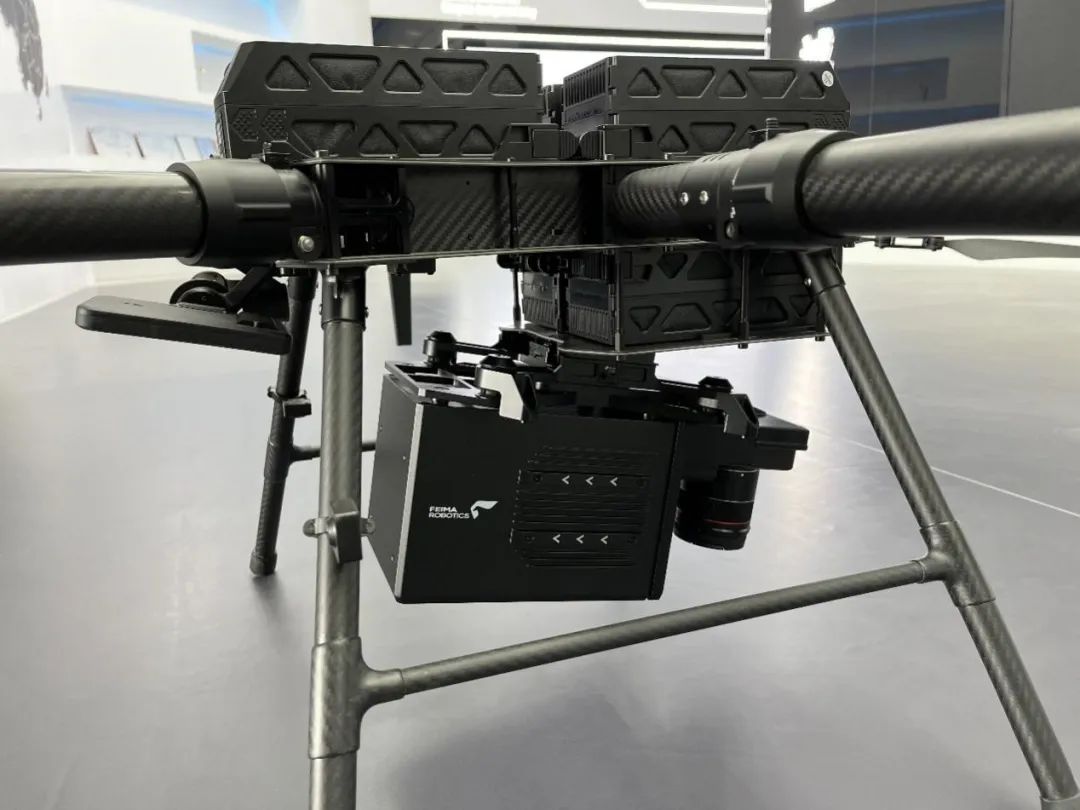
DV-LiDAR10 can not only generate three-dimensional laser point clouds, but also fuse and output color point clouds and orthophotos (simultaneously integrating a 42-megapixel visible light camera), and can perform image mosaics in weak texture areas. In addition, when the DV-LiDAR10 is mounted on the D20 flight platform, the real-time video image below the aircraft can also be viewed through the HGS2000 handheld ground station (the image comes from a 42-megapixel visible light camera).
Universal platform
The DV-LiDAR10 payload design is compatible with the D20 hexacopter flight platform and the V10 vertical take-off and landing fixed-wing platform, and can be installed and mounted through a quick-release structure to achieve quick platform switching. The smart batteries of both platforms are common, which increases customer convenience while reducing cost investment and space costs for field material transportation.
Fully automatic
Continuing Foxtech Robot's consistent integrated design concept, the drone steward's "Smart Route" module automatically completes the calculation of route and DV-LiDAR10 aerial survey parameters, and provides the best default load parameter values during route design; the flight process is controlled by The "Intelligent Flight" module of the human-machine butler is jointly controlled with the D20/V10 flight control system. While supporting precise terrain following flight, it controls the opening and closing of DV-LiDAR10, and automatically divides and names data according to flight zones.
Case operation
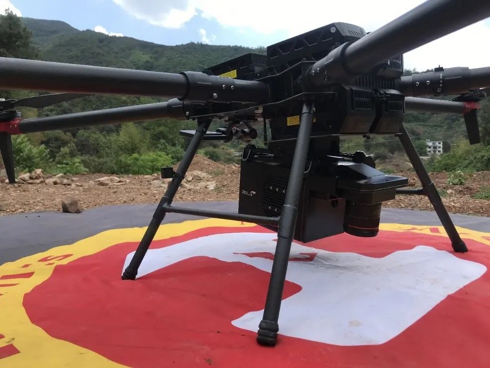
We used D20 to mount DV-LiDAR10 for a flight to appreciate its convenient use process and high-quality data results.
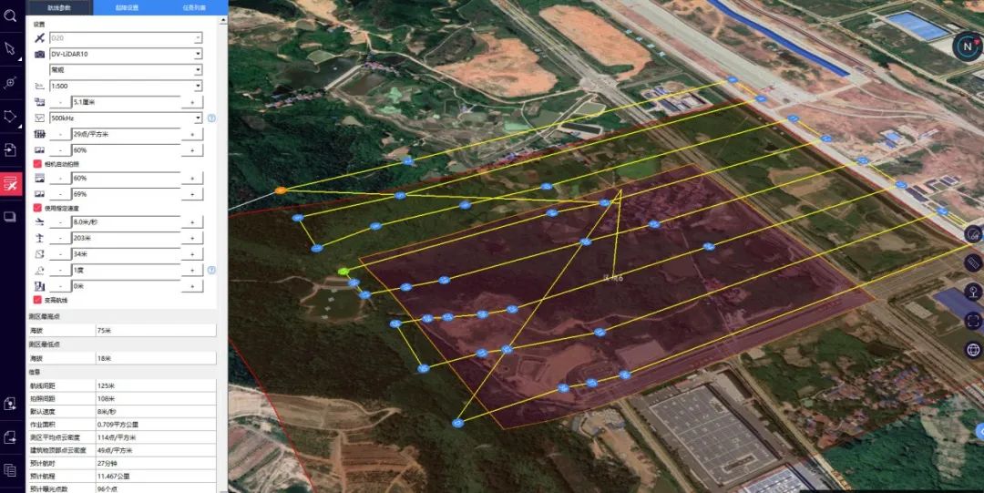
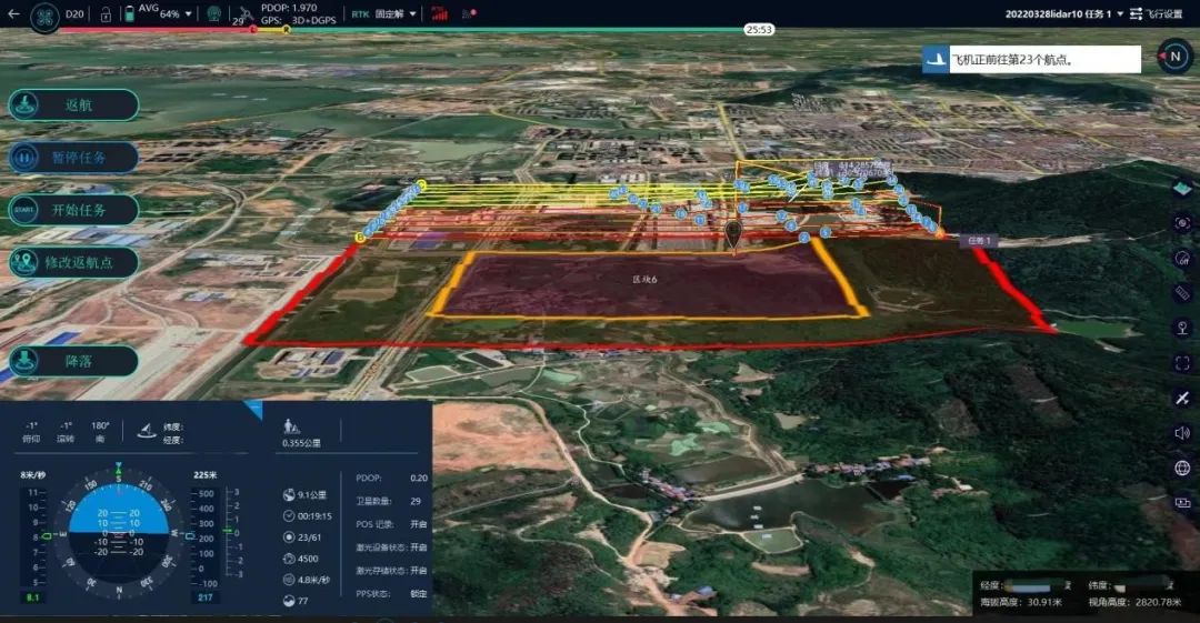
Step 1: Design a route
Draw the measurement area through the "Intelligent Route" module of the UAV Manager, select the flight platform and payload model, set the flight altitude, side overlap rate, and laser point frequency, and the "Intelligent Route" automatically draws accurate terrain following routes (variable altitude routes), And estimate the estimated flight time, number of photo points, average point density and other information. The total area of the flight measurement area is 0.71km², the relative altitude is 200m, and the average point density in the measurement area is expected to be 114pts/m².
Step 2: Assembling the aircraft in the field
Take the D20 aircraft out of the packaging box, unfold and fix the propeller arms, install the DV-LiDAR10, install the smart battery, and power on to complete the preparation of the aircraft and payload.
Step 3: Upload route/take off with one click
In the "Intelligent Flight" module of the drone manager, select the designed route, connect the aircraft, enter the full system self-check, upload the route with one click, and take off with one click. The drone can independently complete data acquisition and land at the take-off point.
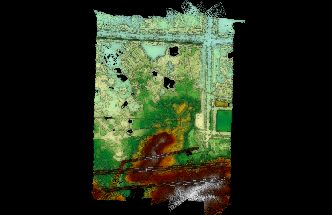
Step 4: Data processing
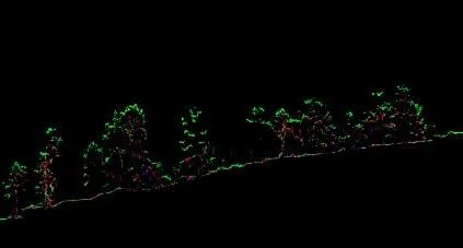
After using UAV Manager's "Intelligent Map" or third-party software to solve the laser trajectory, select or download the calibration parameters of the corresponding load in the UAV Manager's "Intelligent Laser" module, import the original data, and you can solve the problem with one click Calculation, the calculated data is as shown below.
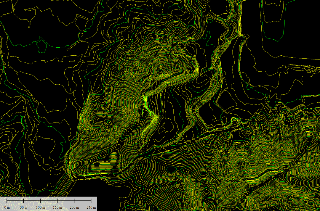
Step 5: Data Check
Use the quality check and accuracy check functions in the "Smart Laser" module of Drone Manager to perform quality checks on the data. The check results are shown in the figure below. The quality inspection chart shows that there is no layering between data flight strips, and the accuracy check shows that the error in elevation is 3.8cm, which meets the accuracy requirements.
Application Scenarios
Many applications can be made based on the above data - we process this set of data and take you through the application scenarios of DV-LiDAR10.
-
Topographic surveying and mapping
-
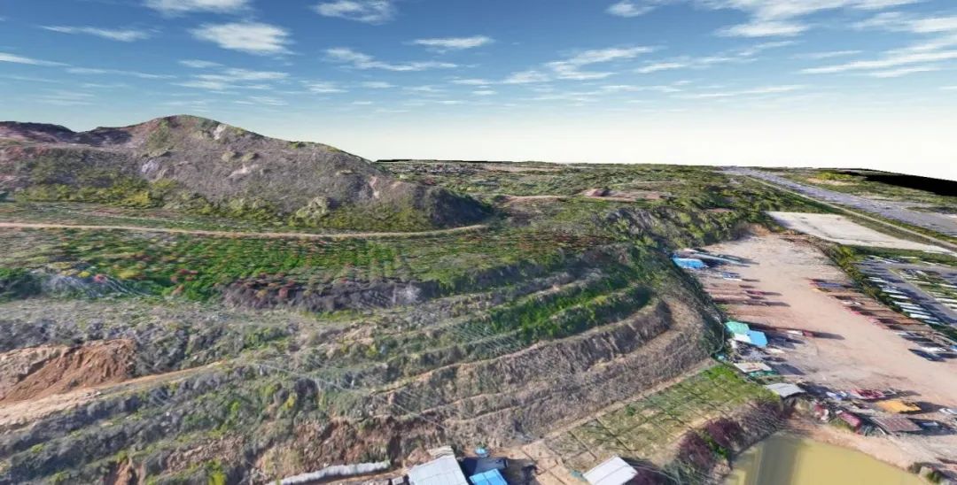
Topographic surveying and mapping is a basic application scenario in the surveying and mapping industry. Achieving high-precision, high-efficiency, and high-density topographic data acquisition is the goal pursued by various manufacturers. DV-LiDAR10 is mounted on the D20 and V10 flight platforms, which can maximize work efficiency and seven-echo penetration. It can be used in most environments with dense forest vegetation to obtain more accurate surface information.
-
 Power line inspection
 -
UAV airborne lasers can collect accurate three-dimensional information at low altitudes, and the lasers can penetrate vegetation canopies, so they are widely used in the power line inspection industry. Power line inspections include inspecting both high-level overvoltage transmission lines and outdoor low-voltage lines. The small light spot and high precision of DV-LiDAR10 are very suitable for power line inspection scenarios and can provide more efficient and accurate line inspection data.
-

 Power line inspection
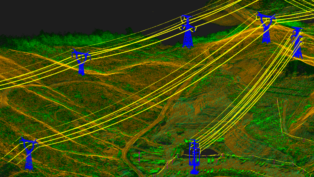
Real 3D
The DV-LiDAR10 payload can acquire high-precision three-dimensional data and fine texture information, and can reproduce the real-life three-dimensional model in the computer. Its characteristics of high altitude, high efficiency and high precision are suitable for carrying out large-scale natural landforms and ecological environments. and the acquisition of urban three-dimensional real-scene data.
HD Map
With the development of autonomous vehicles, the industry's demand for high-precision maps of the road environment is becoming increasingly strong. High-precision maps require centimeter-level three-dimensional information and logical relationships of ground marking lines, and can be quickly updated within a certain period. It is easy to see from the road color point cloud, grayscale point cloud and high-precision road markings collected based on the results in the picture below that DV-LiDAR10's accurate representation of road markings can replace lidar applications in some vehicle scenarios to achieve rapid acquisition. The purpose of high-precision road maps.
DV-LiDAR10 is the first domestic long-range airborne lidar system released by Foxtech Robot. Its high precision and wide range of application fields will surely be proven by time. You are welcome to make an appointment and experience it through the official Foxtech Robot sales system. We look forward to working with you to develop applications in more fields.
