A New Choice for Inspection of Urban Overhead Transmission Lines——SLAM100 Handheld LiDAR Scanner
With the rapid development of cities, urban power supply systems continue to grow at a relatively rapid rate, and the mileage of overhead transmission lines continues to increase, posing greater challenges to line operation and maintenance. Traditional manual inspections mainly rely on manual on-site inspections, with heavy tasks and low efficiency. Especially in urban areas with complex scenes, the efficiency and accuracy are not ideal. UAV airborne LiDAR inspection is very mature for transmission line inspection. Through the integrated process of on-site line inspection, data processing and analysis, rapid identification of line defects can be realized.
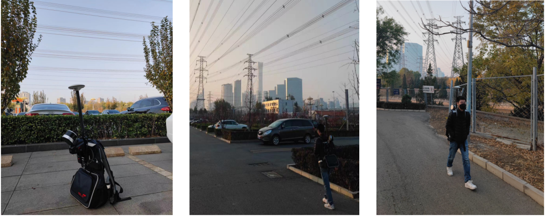
However, there are large environmental differences between urban areas and areas such as mountains and hills. Urban areas are densely populated with people and buildings, and transmission lines and surrounding landforms form a complex interlaced situation, which poses a serious threat to the flight safety of drones. For the inspection of power transmission lines in urban areas, the mobile lidar backpack platform S-PACK100 combined with SLAM100 can adapt to the intricate work scenes in urban areas. Collectors carry S-PACK100 on their backs and walk along the line at a normal pace to realize digital scanning of transmission lines at close range.
With the rapid development of cities, urban power supply systems continue to grow at a relatively rapid rate, and the mileage of overhead transmission lines continues to increase, posing greater challenges to line operation and maintenance. Traditional manual inspections mainly rely on manual on-site inspections, with heavy tasks and low efficiency. Especially in urban areas with complex scenes, the efficiency and accuracy are not ideal. UAV airborne LiDAR inspection is very mature for transmission line inspection. Through the integrated process of on-site line inspection, data processing and analysis, rapid identification of line defects can be realized.
However, there are large environmental differences between urban areas and areas such as mountains and hills. Urban areas are densely populated with people and buildings, and transmission lines and surrounding landforms form a complex interlaced situation, which poses a serious threat to the flight safety of drones. For the inspection of power transmission lines in urban areas, the mobile lidar backpack platform S-PACK100 combined with SLAM100 can adapt to the intricate work scenes in urban areas. Collectors carry S-PACK100 on their backs and walk along the line at a normal pace to realize digital scanning of transmission lines at close range.
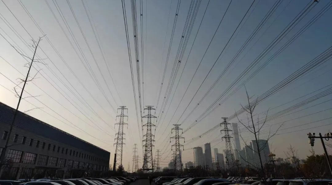
Urban Overhead Transmission Lines
S-PACK100 Introduction
The lidar backpack platform S-PACK100 is a newly launched integrated expansion platform adapted to the SLAM100 mobile lidar scanner. It can support the expansion of the RTK module and the panoramic camera module, mount the SLAM100 lidar scanner, and walk, ride, etc. The operation form carries out the piggyback scanning operation, which not only enriches the operation mode of SLAM100, but also improves the operation efficiency of SLAM100.
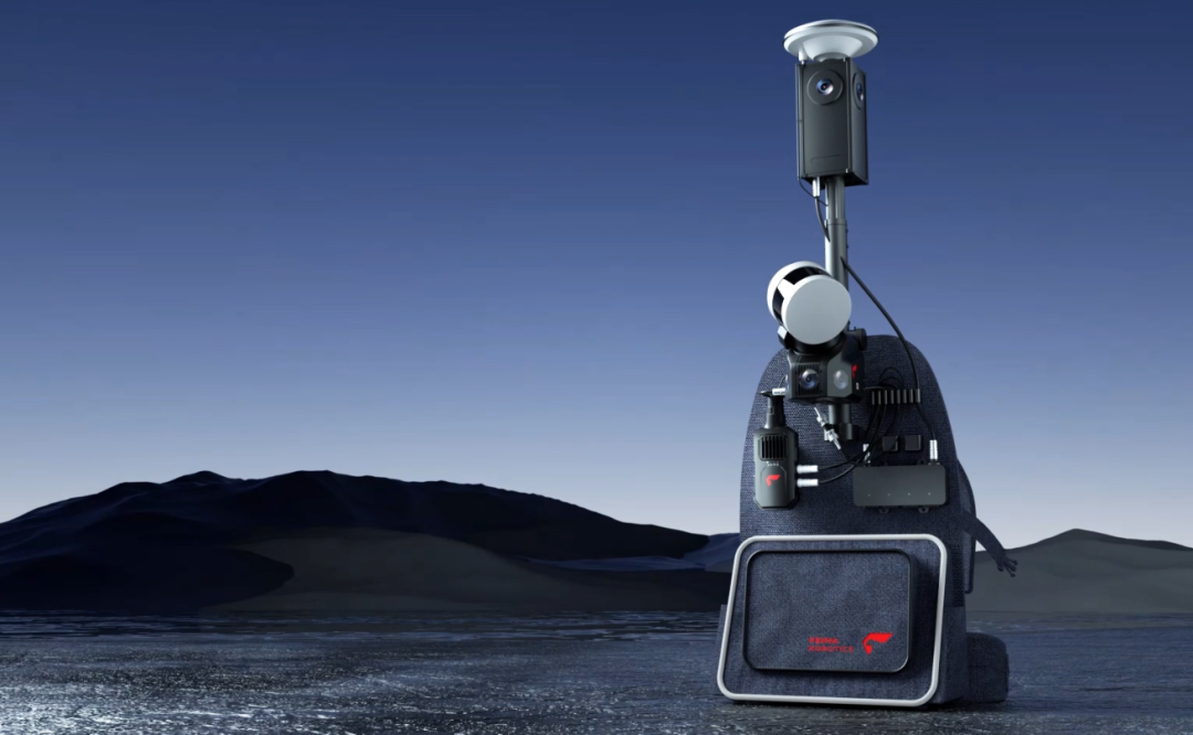
SLAM100+S-PACK100+S-RTK100+S-PANO100
Overview of the Test Area
The test area is located around a large parking lot in a certain city. The voltage level of overhead transmission lines in the area is 220Kv. The target line has a total of 4 base towers, about 1km long. There are two other lines parallel to it on both sides. The buildings and vegetation around the line , There are many roads and human production activities, the line crosses rivers and overpasses, and the environment is complex, reflecting the main characteristics and conditions of urban overhead transmission lines.

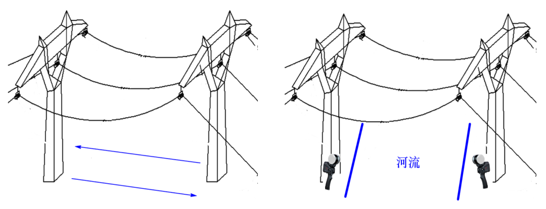
Overview of the Test Area and Route Direction
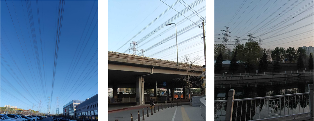
Test Area Environment
Preliminary Preparation - Collection Path Planning
In view of the complex actual situation of the survey area, the collection personnel formulated the collection route by section and area in advance to ensure the integrity of the point cloud results and prevent power line interruption and loss. Collection route planning follows the following principles:
♦ For the normal walkable area (such as inside the parking lot), it is enough to collect normally according to the two sides of the line.
♦ Across overpasses, rivers and other areas, under the premise of ensuring the safety of collectors, get as close to the target line as possible from far to near, and fully acquire data on both sides of overpasses and rivers.
Data Collection Method
Data Collection
Install the SLAM100 together with the backpack platform S-PACK100. After the SLAM100 is turned on, connect to the CORS network to select the port and source node, and put the backpack in an open area to rest for 2-3 minutes, which is convenient for the RTK module to quickly search for satellites and fix it. When the SLAM100 initialization work is completed, the collectors use the backpack platform to obtain data according to the established collection route and rules. During the collection process, they can browse the scanning overview in real time through the mobile phone software SLAM GO APP. The field scanning is divided into 3 areas, which are represented by different colors. 1 (green) scan took 10 minutes, partition 2 (red) scan took 15 minutes, partition 3 (yellow) scan took 15 minutes, a total of 40 minutes.
Field Collection
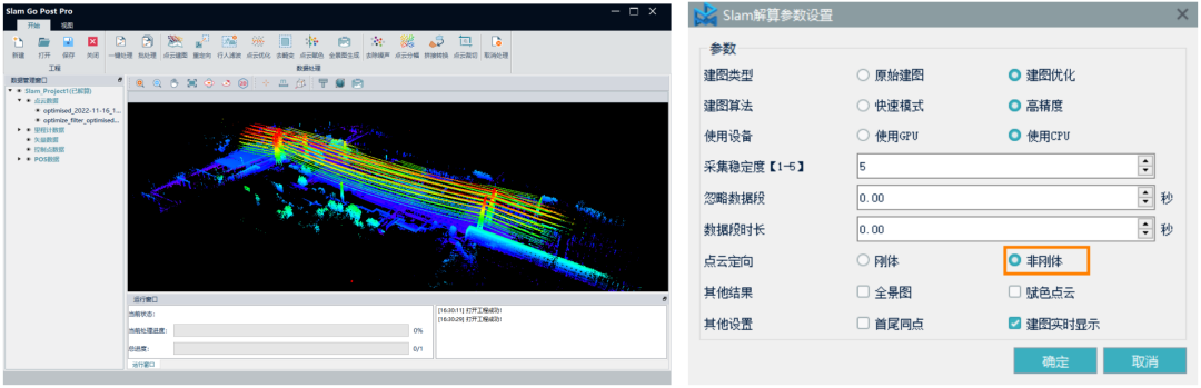
Point Cloud Solution
Use the PC-side supporting software SLAM GO POST Pro to solve the point cloud data with one-click non-rigid transformation based on the RTK trajectory. Non-rigid transformation can not only use the true value of coordinates to eliminate the influence of accumulated errors and improve the accuracy of point clouds, but also directly incorporate point clouds into the absolute coordinate system, eliminating the need for subsequent point cloud registration steps, and accurately merging point clouds in different scanning sequences to meet Power inspection point cloud result requirements.
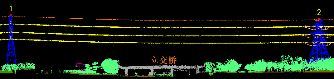
The average point density of the point cloud of the overhead transmission line channel is 980 points/㎡, and the double circuit on the same tower is quickly drawn, and the power lines across the river and overpass are complete and continuous without interruption.
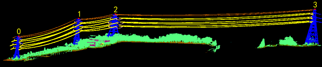
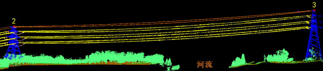
The point cloud data of overhead transmission line channel conductors, ground wires, jumpers, towers, and insulators are clearly covered, the structure is complete, and the four-split conductors are clearly visible.
Accuracy Check
Match the point cloud with the GNSS-RTK measured corner points of the tower base (the red points are the measured checkpoints, a total of 16), and compare and check the accuracy of the point cloud. The error in the plane of the point cloud is 5.3cm, and the error in the elevation is 4.7cm.
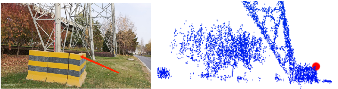
Point Cloud and Checkpoint Fit
Summary and Outlook
The high-precision point cloud data obtained based on SLAM100 fully meets the needs of power inspection services. Its portability, GPS-free, and multiple platforms allow it to be applied to urban main networks and distribution networks where flight cannot be carried out in complex environments. Transmission line inspection. Compared with the large-scale application of UAV airborne LiDAR technology in power inspection, it is more of a supplementary technical means. In addition, SLAM100 can conduct fine-grained scanning for power equipment such as towers and substations, accurately obtain the shape, outline and geometric dimensions of line fittings, build three-dimensional models of towers and substations, and establish digital ledgers for power transmission equipment to help the development of smart grids.
